
What you'll see on your journey
The beautiful scenery and interesting landmarks you'll see during the crossing.
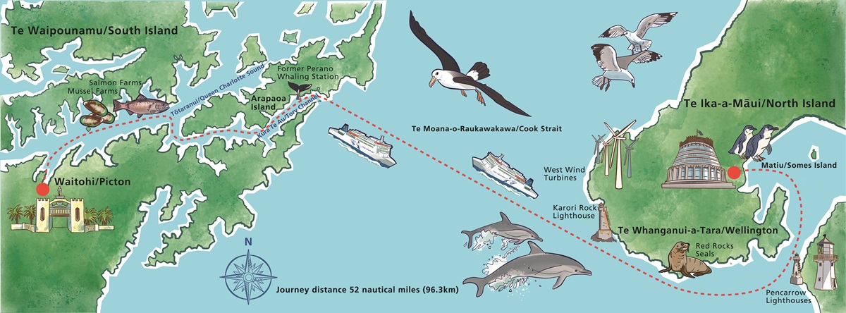

One of the most scenic ferry journeys in the world
The Cook Strait ferry crossing is 96 kilometers (52 nautical miles) and takes around three and a half hours.
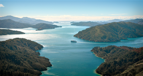
Two-thirds of the journey is a scenic spectacle, with the ferry looping around Wellington Harbour and drifting through the fjord-like channels and inlets of the Marlborough Sounds.
The remaining third of the journey is spent navigating Te Moana o Raukawakawa / Cook Strait - a seafaring adventure through a dramatic and rugged channel where the Tasman Sea meets the Pacific Ocean.
The Cook Strait crossing is a must-do experience for New Zealand locals and international visitors alike. Travelling North to South, here are a few of the places and landmarks you'll see.
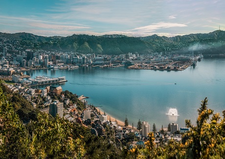
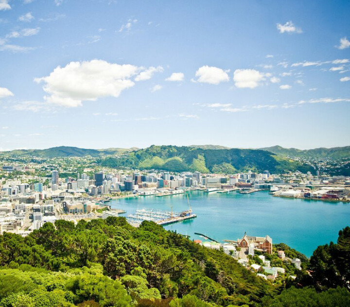
Few cities in the world can claim to be scenic, but thanks to its amazing natural harbour, Whanganui-a-Tara/Wellington certainly can.
Wellington is completely surrounded by lush green hills and sparkling waters. This protected harbour has attracted many explorers over the centuries, from the legendary Kupe to the first settler ships that moored upon the beaches of Petone, each has found sanctuary in the calm waters of Wellington Harbour.
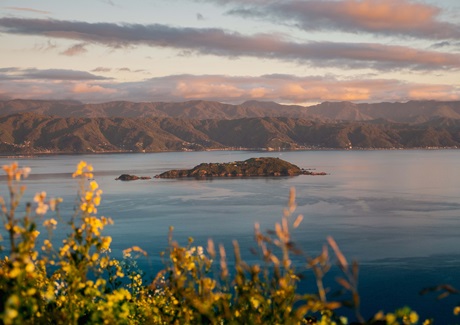
Matiu/Somes Island was originally used by Māori for gathering seafood and other resources, as well as providing a safe haven during times of conflict. Its position allowed Māori to monitor movements in the harbour, making it an important site for defense and communication.
In the late 1800s and early 1900s, it served as a quarantine station for diseases and an internment camp during both World Wars.
Today, Somes Island is a conservation area focusing on restoring native plants and animals. Predator-free since the 1980s, it now hosts species like tuatara and the Cook Strait giant wētā. Managed by the Department of Conservation, the island is open to the public for visits and learning.
Photo credit: Wellington NZ
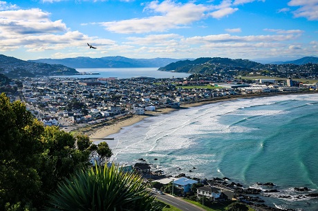
As you leave Wellington Harbour, on starboard (right) side, you'll catch glimpses of Wellington's beautiful Oriental Bay, followed by the beach suburbs along Miramar Peninsula and beyond.
Sailing past Scorching Bay, Seatoun, Lyall Bay and Island Bay, each area has it's own unique character and the beach suburbs are a charming mixture of costal living and community spirit.
Photo: View of Lyall Bay Beach. Credit: Celeste Fontein
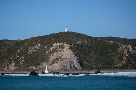
On the port side as you leave Wellington Harbour, sitting on top of the hill you'll see New Zealand's first lighthouse. Erected in 1858, Pencarrow Lighthouse was constructed in England and shipped to New Zealand in 480 segments.
Back then, Pencarrow Lighthouse was run by New Zealand's only female lighthouse keeper along with her six children.
The Lower Pencarrow Lighthouse was built on the beach below in 1906 to be used during the frequent foggy conditions that rendered the hilltop lighthouse useless.
- Wellington to Picton, approx. 30 minutes into the journey
- Picton to Wellington, approx. 2 hours 50 minutes into the journey
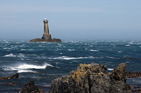
Just below West Wind Farm, you may catch a glimpse of Karori Rock Lighthouse standing atop a rocky promotory.
Karori Rock Lighthouse, sometimes know as the 'Leaning Lighthouse', was opened in 1915. The lighthouse was intentionally built on a lean to make the ladder easier to climb.
Standing 20 metres above sea level and sloping slightly to the east, the structure was designed for the strength required to withstand the wild winds that can blow through Te Moana o Raukawakawa / Cook Strait.
After over eighty years' in operation, Karori Rock Lighthouse was decommissioned in May 1996 and replaced with a new flashing beacon on the mainland at Tongue Point.
- Wellington to Picton, approx 1 hour 5 minutes into the journey
- Picton to Wellington, approx. 2 hours 15 minutes into the journey
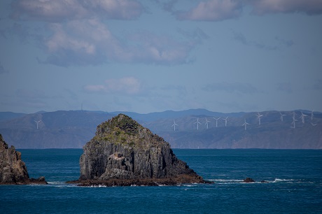
As you leave Wellington Harbour and head along the South Coast, you begin to catch a glimpse of the 62 towering wind turbines that make up Meridian's West Wind.
Construction on West Wind began in October 2007, and two years later, all 62 turbines were operational, powering 73,000 average New Zealand homes each year.
The strong funnelling effect of Cook Strait provides the wind farm with powerful, and more importantly, consistent wind speeds making it the perfect place for generating renewable electricity.
- Wellington to Picton, coming into view approx. 1 hour 15 minutes into the journey
- Picton to Wellington, coming into view approx. 1 hour 40 minutes into the journey
Te Moana o Raukawakawa/Cook Strait is the rugged channel between New Zealand's North and South Islands where the Tasman Sea and the Pacific Ocean meet. Described as one of the most violent and unpredictable stretches of water in the world, it is a remarkable and beautiful journey - and wonderfully calm, most of the time.
And the inter-island ferry isn't the only way to cross Cook Strait. Every year a number of intrepid swimmers set out to conquer this challenging stretch of water. And those who succeed are acknowledged with a lifetime of free crossings through Interislander's Freedom of the Ferries.
Cook Strait halfway point
- Wellington to Picton, approx. 1 hour 40 minutes into the journey
- Picton to Wellington, approx. 1 hour 40 minutes into the journey
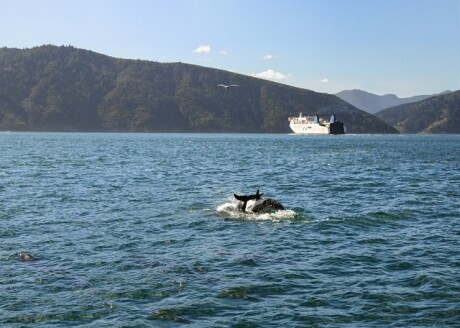
There are few ferry journeys around the world that you will board expecting to see dolphins, albatross, and whales. And while you should temper your expectations, as there are no guarantees, sightings are very regular.
During the winter months, whales can be seen migrating through Cook Strait. You may also catch a glimpse of an albatross (Toroa), the world's largest seabird. With a wingspan of over three metres, they're hard to miss.
Throughout the year sightings of dolphins in the Tory Channel and Queen Charlotte Sound are very regular.
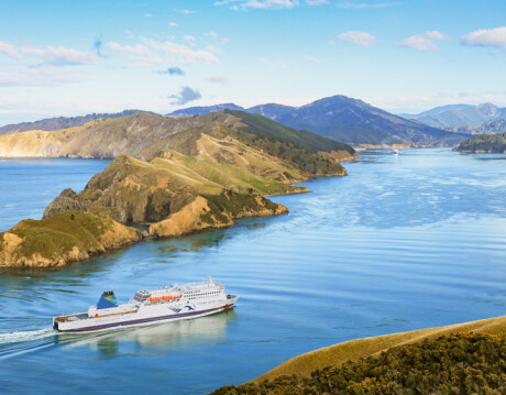
The gateway between Cook Strait and Tory Channel is a narrow entrance between two heads - East Head and West Head. This craggy entrance is northward from Cook Strait, and so the small bird-covered island on the right-hand side is East Head.
Interislander turns a sharp 90 degrees to go through the entrance and, on approach from either direction, it looks like the ferry is on a collision course with the huge rolling Marlborough hills.
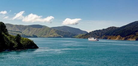
Kura Te Au/Tory Channel is, without doubt, the most stunning section of the Cook Strait crossing.
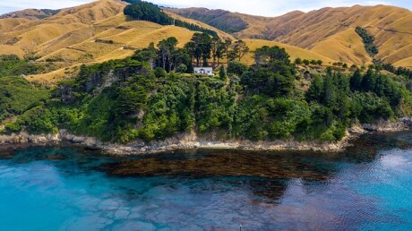
Meandering through this narrow protected channel is rightly compared with the fjords of Scandinavia. With glorious hills of Marlborough rising on either side, and just a few isolated holiday retreats dotting the shores, this is one of the most remote and beautiful regions in New Zealand - and only able to be visited by boat.
As you pass through Tory Channel and into the Sounds, look out for the work of the Marlborough Sounds Restoration Trust and their work to eradicate Wilding Pines and restore the natural environment and biodiversity of the Sounds.
- Wellington to Picton, entering Tory Channel East Head approx. 2 hours 10 minutes into the journey
- Picton to Wellington, exiting Tory Channel East Head approx. 1 hours 20 minutes into the journey
As Interislander sails into Tory Channel, it is facing Arapaoa Island, the second largest island in the Marlborough Sounds.
Arapaoa Island, and the Arapaoa Kiwi Trust, has undertaken an ambitious 7-year project to reintroduce native kiwi to this natural, unspoiled environment.
Critical to making this a success is the eradication of stoats threaten our flightless native kiwi. Stoats have been known to swim the 2.5km from the mainland!
Interislander is supporting the Trust by helping to install more than 1,500 traps and about 100 cameras across the island to identify and eradicate these predators. Only once the island has been stoat-free for at least three years will it be safe for kiwi to be released.
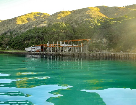
Just inside Tory Channel, you may spot the skeletal remains of buildings are all that are left of New Zealand’s last whaling operation.
Established in 1923, the Perano Whaling Station became a small village with many whalers and their families living on site. Their catch was mainly Humpback whales during the annual migration through Cook Strait. More than 3,500 whales were hauled to shore here to be processed for baleen and whale oil.
Whaling continued in New Zealand until 1964 and it was not until 1978 that whales became fully protected within New Zealand’s 200 Nautical Mile economic exclusion zone.
Whaling only ended because it became uneconomic, with fewer whales migrating through Cook Strait and alternative raw materials available.
The hut on Perano Head is now used for conservation, supporting the counting and tagging Humpback whales as their numbers slowly rebuild.
- Wellington to Picton, approx. 2 hours 50 minutes into the journey
- Picton to Wellington, approx. 1 hour 15 minutes into the journey
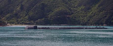
King salmon (Māori names: Hāmana or Tāmana), have been farmed in the Marlborough Sounds for more than 25 years.
Salmon thrive in cool, clear, flowing water which makes the Sounds a perfect growing environment.
Salmon are hatched in fresh water and then transferred to the large sea pens you'll see as you travel through Queen Charlotte Sound. When fully grown, the salmon are harvested and sent to Nelson for processing.
- Wellington to Picton, approx. 2 hours 30 minutes into the journey
- Picton to Wellington, approx. 1 hour into the journey
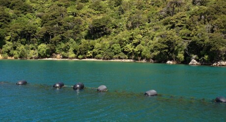
As you head out of Tory Channel and into Queen Charlotte Sound, you may spot clusters of large oval buoys; the only sign of the substantial mussel farms underneath these tranquil waters.
Since the early 1970s, the Marlborough Sounds has been considered an ideal location for farming green-lipped mussels (kūtai).
This species, which for hundreds of years has formed part of traditional kaimoana for Māori, is farmed for its food value and as a health supplement. The mussels grow on lines below the surface attached to ropes that are kept afloat by the large buoys you see.
The mussel industry is the second-largest in Marlborough, with over 500 farms producing around 70% of the national harvest.
- Wellington to Picton, approx. 2 hours 45 minutes into the journey
- Picton to Wellington, approx. 45 minutes into the journey
The broad and beautiful Tōtaranui/Queen Charlotte Sounds leads from Picton to the Tasman Sea. This idyllic and calm stretch of water was Captain Cook's favoured sanctuary on his three voyages to New Zealand. Little has changed and apart from the occasional holiday home and nature retreat you'll see very little sign of civilisation along this route.
On the western banks, the Queen Charlotte Track is one of New Zealand's great hiking and biking trails.
- Wellington to Picton, entering Queen Charlotte Sound approx. 2 hours 50 minutes into the journey
- Picton to Wellington, exiting Queen Charlotte Sound approx. 35 minutes into the journey
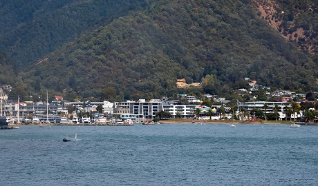
At the southern end of the journey is Waitohi/Picton, a sleepy fishing town at the end of the Queen Charlotte Sound. Although inter-island ferries come and go throughout the day, the town remains quiet and is a surprisingly idyllic place to stay or enjoy a few hours of calm.
Picton is also the gateway to the Marlborough Sounds, with water taxis departing regularly for the holiday spots dotted amongst the silent bays and inlets lining the Queen Charlotte Sound.
Things to do on either side of the Strait
National Parks
For a quintessential South Island itinerary, it’s hard to look past the incredible national parks.